Drone RTK provides superior precision for government surveys, achieving 1 to 5 cm horizontal and vertical accuracy compared to the 1 to 3 meter range offered by standard satellite imagery. This significant improvement in drone RTK GIS accuracy vs satellite Saudi Arabia ensures survey-grade mapping for complex urban planning projects across the Kingdom. These drones utilize real-time corrections to deliver centimeter-level detail; this allows for absolute spatial accuracy where standard satellite data falls short.
When a government project stalls because survey data doesn't hold up under scrutiny, the cost isn't just financial, it's measured in delayed infrastructure, revised permits, and eroded confidence in the planning process. For urban planners and survey engineers working across Saudi Arabia's rapidly expanding cities, the choice between drone RTK GIS and satellite-based mapping is no longer a technical footnote; it is a foundational project decision. With Vision 2030 raising the bar on development precision from NEOM's master-planned corridors to municipal boundary surveys in secondary cities, understanding exactly where each technology performs, and where it falls short, is critical. In this article, you will learn how these two methods compare on accuracy, workflow integration, and practical suitability for Saudi government survey requirements.
The Accuracy Gap That Matters for Saudi Urban Planning
For government survey teams and urban planners working across Saudi Arabia, choosing between drone RTK GIS and satellite GIS data is rarely a purely technical decision. It carries direct consequences for project compliance, construction tolerances, and budget exposure when errors surface late.
At sites like NEOM's linear infrastructure, the Diriyah Gate heritage zone, and ongoing Riyadh Metro corridor expansions, spatial data errors are not corrected cheaply. A positional mistake of even half a meter can invalidate a cadastral submission, misalign a utility corridor, or trigger costly redesign on an engineered slope. GEOSA, the General Authority for Survey and Geospatial Information, sets the accuracy thresholds that government survey deliverables must meet, and standard satellite imagery sources fall well outside those thresholds for most engineering-grade applications.
The question of drone RTK GIS accuracy vs satellite in Saudi Arabia comes down to a fundamental mismatch in what each technology was built to deliver. The sections below break that gap down precisely, starting with a direct comparison of the numbers that procurement teams and project engineers actually need to evaluate.
TL;DR: RTK Drone GIS vs Satellite GIS at a Glance
The numbers below cut through the technical detail for procurement teams and engineers who need a fast reference before going deeper.
Factor | RTK Drone GIS | Satellite GIS |
|---|---|---|
Horizontal accuracy | 1–3 cm | 3–20 meters |
Vertical accuracy | 2–5 cm | 10+ meters (often worse) |
Data freshness | Captured on demand | Potentially 3–6 months old |
Weather dependency | Operable in clear, low-wind conditions | Blocked by cloud cover and shamal dust events |
Output formats | GeoTIFF, LAS/LAZ, DXF, BIM-compatible mesh | Raster tiles |
For government survey work in Saudi Arabia, the horizontal accuracy gap alone, measured in centimeters against meters, is the defining constraint. The sections below explain what drives those numbers and where each method genuinely holds up under real project conditions.
How Accurate Is Drone RTK Surveying: Breaking Down the Numbers

Those comparison figures from the previous section only hold when the RTK system is working correctly. Understanding what drives that performance, and where it can degrade, is what separates a technically sound survey from one that fails a GEOSA submission.
RTK works by pairing the drone's onboard GNSS receiver with a ground base station or a CORS network that transmits live satellite correction signals during the flight itself. Standard GPS, with no correction applied, produces 1 to 3 meter horizontal error under typical open-sky conditions. RTK corrections close that gap down to 1 to 3 cm horizontal and 2 to 5 cm vertical in real time. Geonadir benchmarks RTK drone surveys at 1 to 2 cm horizontal accuracy under controlled conditions, which is the figure that makes engineering-grade deliverables possible.
Adding GCPs, physical targets measured by a total station or calibrated GNSS receiver and distributed across the survey area, allows photogrammetric processing software to validate and refine the model further. In ideal flat terrain with good satellite geometry, GCP-assisted processing can push accuracy into sub-centimeter range. For RTK drone mapping services in Saudi Arabia, GCPs are particularly valuable on larger sites where accumulated positional drift might otherwise introduce systematic error.
PPK, Post-Processed Kinematic, applies the same correction mathematics after the flight by logging raw satellite observations and processing them against a base station log offline. It achieves equivalent accuracy to RTK but does not require a live correction link during the mission. This makes PPK the preferred method in areas where radio or cellular correction links are intermittent.
Three failure modes are worth flagging directly for Riyadh survey conditions. Multipath error occurs when GNSS signals reflect off building facades in dense urban environments before reaching the receiver, introducing positional noise that neither RTK nor PPK can fully eliminate. Poor satellite geometry, quantified as high PDOP values, reduces the effective number of satellites contributing useful corrections and degrades both horizontal and vertical precision. Vertical bias is the most persistent issue: even when horizontal accuracy meets tolerance, vertical accuracy typically runs 1.5 to 2 times worse, which has direct implications for drainage and earthwork calculations where elevation data carries the most weight.
Why Satellite GIS Falls Short for Fine-Grained Urban Surveys

The RTK accuracy figures covered above assume a technology matched to the task. Satellite imagery, by contrast, carries structural constraints that no processing pipeline can overcome, and those constraints matter significantly when evaluating drone RTK GIS accuracy vs satellite Saudi Arabia use cases at the government survey level.
Even the best commercial satellites available today fall short of engineering-grade requirements. Maxar WorldView-3 and Planet's SkySat constellation represent the premium tier of commercial satellite imagery, yet they deliver 30 to 50 cm ground sample distance at best, with practical positional accuracy in the 3 to 5 meter range once atmospheric distortion, satellite attitude error, and terrain relief displacement are factored in. Standard commercial imagery integrated into common planning tools, including regional basemaps used across government GIS platforms, typically carries 10 to 20 meter positional accuracy. That gap is not a minor calibration issue; it is the difference between resolving a property boundary and missing it by the width of a building.
Weather compounds the problem in ways that are particularly relevant to Saudi Arabia. Shamal dust events, which occur across central and northern Saudi Arabia multiple times per year, can render satellite optical sensors completely ineffective for days at a time. Winter cloud cover over the Arabian Gulf coast creates additional collection gaps. Unlike a drone crew that can be scheduled around a clear morning window, a satellite revisit opportunity lost to dust or cloud cover means waiting weeks for the next usable pass.
Temporal resolution creates a separate category of failure on active construction sites. Satellite data for a given area may be 3 to 6 months old by the time it reaches a planning workflow. In Riyadh's northern expansion zones, where earthworks and road alignments change week by week, that lag makes satellite imagery operationally useless for progress monitoring or as-built verification.
Spectral limitations further restrict satellite utility at the parcel level. Distinguishing land use categories at the individual plot scale, separating paved surfaces from compacted gravel from exposed fill material on a construction site, requires spatial resolution that commercial satellite sensors cannot consistently deliver.
Satellite data remains genuinely useful for regional land classification, large-area change detection across desert terrain, and initial site screening before mobilizing field resources. The limitation is specific: it is not a tool for parcel-level surveys, as-built documentation, or any deliverable that requires accuracy within GEOSA submission tolerances.
When Saudi Government Agencies Should Choose Drone RTK Over Satellite Data

The limitations outlined above translate directly into a procurement decision. The practical question for government engineers and project managers is not which technology is more sophisticated; it is which one meets the deliverable requirement at hand.
Drone RTK is the appropriate choice in five specific scenarios that arise regularly across Saudi government survey work.
Cadastral and land registration surveys submitted to GEOSA require sub-10-cm positional accuracy. No commercial satellite source meets that threshold. Drone RTK surveys with GCP validation do.
BIM and infrastructure design workflows depend on as-built conditions captured at engineering tolerances. When a structural engineer or MEP contractor needs existing site geometry to feed into an Autodesk or Bentley model, satellite raster data cannot supply it. A classified point cloud from a drone RTK survey can.
Road and utility corridor surveys in Riyadh require resolving features at curb-line level, meaning lane widths, kerb offsets, and utility trench alignments. At 3 to 5 meter satellite positional accuracy, those features simply do not exist in the data.
Construction progress monitoring on Vision 2030 sites demands weekly or bi-weekly data capture on active earthworks. A satellite revisit cycle measured in weeks, subject to dust and cloud gaps, cannot support milestone verification or earthwork volume calculations on that cadence.
Flood risk and drainage modeling in low-relief terrain is where vertical accuracy becomes critical. In areas with less than 2 meters of relief across a catchment, a 1-meter elevation error in the input dataset produces fundamentally incorrect hydrological outputs. The 2 to 5 cm vertical accuracy of drone RTK surveys is not a refinement in this context; it is a functional requirement.
Satellite data remains the practical choice for regional land classification across large desert areas, multi-year change detection at the landscape scale, and initial site screening before committing drone surveying solutions for government projects to a mobilization. The key is matching the tool to the tolerance, and for parcel-level or infrastructure-grade work, that match consistently points toward drone RTK.
Output Formats: What Drone RTK GIS Delivers for Planning Workflows

The procurement decision in the previous section hinges partly on whether drone RTK outputs actually fit into existing agency workflows. They do, but the integration requires delivering the right file formats, in the right coordinate system, and at tolerances the receiving software can use.
A drone RTK survey produces five primary deliverable types.
Orthomosaic GeoTIFFs georeferenced to sub-5-cm accuracy, ready for direct ingestion into Esri ArcGIS. This matters because ArcGIS is the dominant GIS platform across Saudi municipalities, MOMRA, and most government project management offices.
Classified LAS/LAZ point clouds at densities typically ranging from 200 to 800 points per square meter, suitable for 3D terrain modeling, feature extraction, and volumetric analysis.
DXF/DWG CAD files derived from point cloud or photogrammetric processing, formatted for direct use in AutoCAD Civil 3D and similar engineering design environments.
BIM-compatible mesh models in formats accepted by Autodesk Revit and Bentley ContextCapture, enabling as-built conditions to feed directly into structural and infrastructure design workflows.
Contour maps at 10 to 25 cm vertical intervals, generated from the classified point cloud and suited to drainage design and earthwork planning at engineering tolerances.
All of these datasets can be delivered referenced to the ITRF/GRS80 datum that GEOSA requires for government survey submissions in Saudi Arabia. Coordinate system alignment is not an afterthought; it determines whether a dataset passes a GEOSA review or requires costly reprocessing.
For teams assessing drone survey coverage areas across Saudi Arabia, the deliverable stack above is what separates a survey-grade drone operation from aerial photography with a GPS tag attached.
Drone RTK Mapping and Vision 2030: Precision Surveying for Saudi Arabia's Biggest Projects

The deliverable formats described above only hold value when the data underpinning them is current and accurate at engineering tolerances. On Vision 2030 development sites, both conditions must be met simultaneously and repeatedly across the project lifecycle.
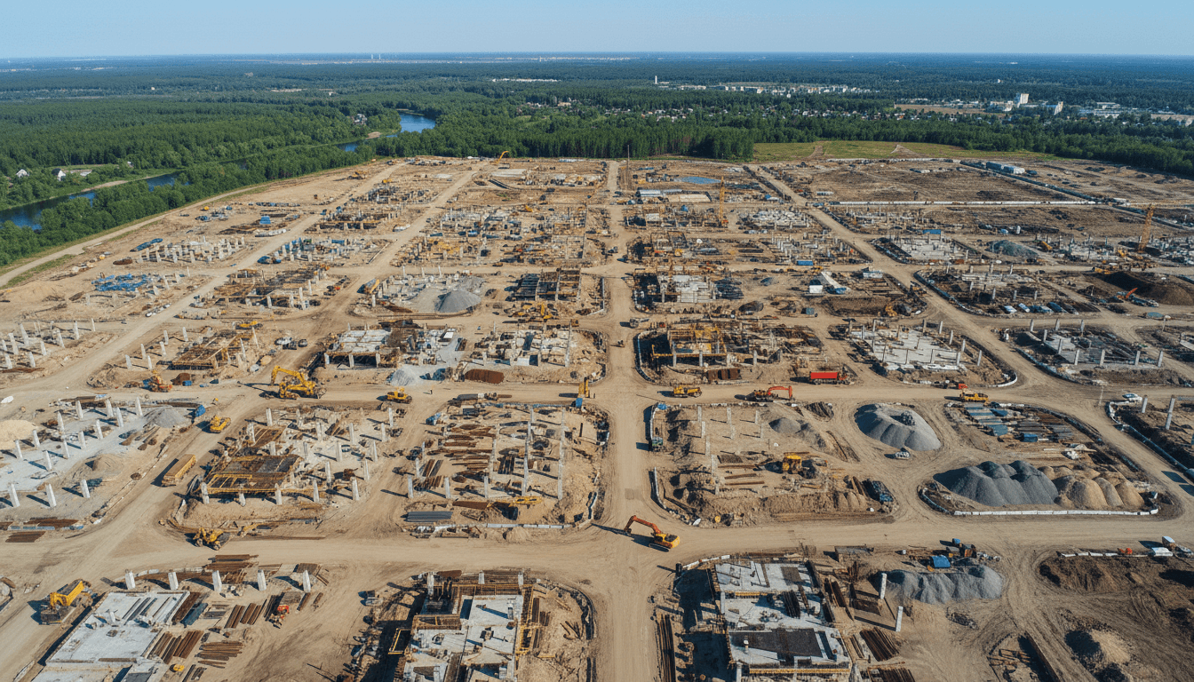
Large-scale projects like NEOM, Diriyah Gate, and the expanding developments across Riyadh's northern and northwestern corridors share a common surveying challenge: they move fast, across large areas, with multiple contractors working in parallel. King Salman Park, the King Abdullah Financial District, and Qiddiya each involve simultaneous earthworks, infrastructure installation, and structural construction across dozens of parcels at once. Maintaining accurate, up-to-date spatial datasets across that kind of activity is not achievable with satellite revisit cycles measured in weeks.
Four specific survey tasks drive the requirement for high-frequency drone RTK data on these sites. Construction milestone verification requires comparing as-built conditions against design drawings at a given date, often tied to contract payment schedules. Earthwork volume calculations depend on comparing successive terrain models at centimeter-level vertical accuracy; a 1-meter elevation error in the input dataset produces volume errors that translate directly into procurement disputes. Site boundary compliance checks confirm that construction activity stays within permitted limits, a requirement that GEOSA-aligned positional accuracy must support. Infrastructure as-built records capture installed utilities and structures before they are buried or enclosed, at tolerances that engineering handover documentation demands.
Majed Aerial Solutions is based in Riyadh, which allows rapid mobilization to northern and northwestern expansion sites as well as other project locations across the region. All survey deliverables are referenced to the ITRF/GRS80 datum for direct GEOSA submission, removing the reprocessing step that often delays government project handovers.
Choosing the Right Surveying Method for Your Project in Saudi Arabia
The five factors below give procurement teams and government engineers a direct framework for matching method to requirement before committing to a survey approach.
Factor | Choose Drone RTK | Choose Satellite |
|---|---|---|
Project scale | Under 500 km2 for survey-grade output | Regional screening above that threshold |
Required accuracy | Sub-meter or GEOSA-compliant tolerances | General overview or change detection only |
Timeline urgency | On-demand mobilization within days | Acceptable when revisit lag and cloud gaps are tolerable |
Budget framing | Higher mobilization cost; lower cost per accuracy unit at engineering tolerances | Lower upfront cost; high reprocessing risk if accuracy fails review |
Regulatory compliance | GAACA-licensed operator required for government surveys in KSA | Licensing requirements vary by data source and application |
The core logic across all five factors is the same: when a deliverable must meet engineering or cadastral tolerances, drone RTK GIS accuracy vs satellite Saudi Arabia is not a close comparison. The accuracy gap is structural, not incremental.
For projects where the right method is not immediately clear, consulting a GAACA-licensed provider early in the planning phase avoids the more expensive mistake of collecting data that fails a GEOSA submission or cannot be ingested into an ArcGIS or BIM workflow. Drone surveying solutions for government projects should be scoped against specific deliverable requirements, not general capability claims.
While satellite imagery remains a valuable tool for broad geographic context, the precision required for modern Saudi urban planning and government surveying is best met by Drone RTK GIS. Choosing the right technology ensures that your projects rest on a foundation of accurate, high-resolution data. If you are looking for expert guidance on implementing these advanced workflows, Majed Aerial Solutions is here to assist. You can explore our specialized الحلول الجوية to see how professional drone surveys can elevate your next project with unmatched detail and reliability.