Drone mapping construction Riyadh enhances site intelligence by delivering centimeter-level accuracy through RTK surveying and BIM-ready data for Saudi megaprojects. GACA-licensed operators provide essential thermal inspections and photogrammetry services that accelerate timelines while ensuring regulatory compliance. These advanced aerial solutions enable smarter decision-making and more efficient resource management throughout the construction lifecycle.
Construction projects in Riyadh move fast, and outdated survey data, missed progress milestones, and non-compliant aerial operations can cost your team weeks and significant budget. If you are managing a large-scale development across the city, whether a giga-project site, an industrial facility, or a commercial build, the accuracy of your spatial data directly determines the quality of every decision downstream. Drone mapping has changed what is possible on active construction sites, but only when it is executed with the right equipment, the right processing workflow, and a fully GACA-licensed operator. In this article, you will learn exactly how RTK drone surveying delivers centimeter-level accuracy, how raw flight data becomes BIM-ready output, and what to look for when selecting a drone mapping partner in Riyadh.
What Drone Mapping Delivers on a Riyadh Construction Site
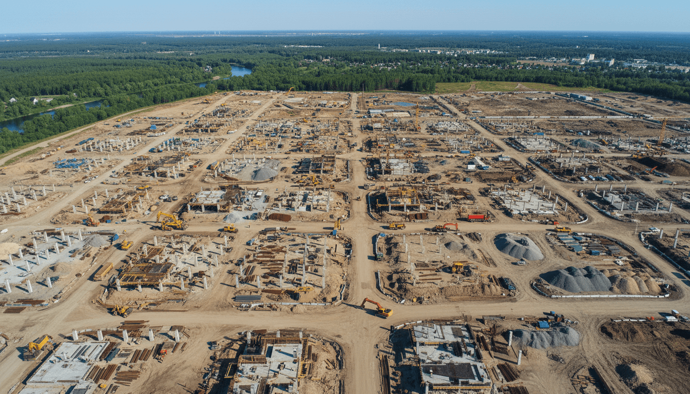
Riyadh's construction managers are operating under conditions that have no real precedent in the region's history. Sites across King Abdullah Financial District, King Salman Park, and the outer ring-road expansion corridors are running on compressed schedules, covering terrain that shifts from sabkha flats to rocky outcrops within the same project boundary, and feeding data into digital workflows that simply cannot tolerate the lag of traditional ground-based survey methods.
A single drone mapping mission over an active site delivers outputs that would take a ground crew several weeks to produce manually. From one flight session covering hundreds of hectares, you get a georeferenced 2D orthomosaic accurate enough for quantity surveying, a dense 3D point cloud for structural review, a Digital Surface Model capturing every element above grade including stockpiles and equipment, and a Digital Terrain Model representing the bare earth beneath. Layered on top of these is volumetric cut-and-fill analytics, which quantifies earthworks movement against design grades without requiring a surveyor to set foot in a potentially hazardous excavation zone.
For drone mapping construction Riyadh projects operating under Vision 2030 delivery timelines, the practical value is direct: geospatial data that feeds into BIM and GIS workflows within hours of the flight, not weeks after a field campaign concludes.
How RTK Drone Surveying Achieves Centimeter-Level Accuracy

An RTK drone typically achieves 2 to 5 cm horizontal and vertical accuracy by receiving real-time GNSS correction signals from a base station or network, removing the positional drift that affects standard GPS-equipped platforms. In practical terms, this means a single aircraft can produce survey-grade data across a large site without requiring a surveyor to place and measure dense networks of ground control points across the entire area.
For comparison, a traditional total station survey delivers comparable point accuracy but captures data sequentially, one measured position at a time. On a site covering tens of hectares, that sequential process takes days or weeks. RTK drone surveying compresses that timeline to a single flight session while maintaining the accuracy thresholds that engineering workflows require.
Ground control points still serve an important function, though not as the primary accuracy mechanism. Placed at known coordinates and measured independently, GCPs act as validation checkpoints that confirm the drone dataset is performing within specification. Most rigorous survey deliverables include a checkpoint report alongside the spatial data.
Where RTK signal becomes intermittent, such as in deep excavation zones or sites near tall structures that obstruct satellite geometry, PPK (Post-Processed Kinematic) processing offers a reliable alternative. Rather than applying correction in real time, PPK applies it during office processing using logged base station data, achieving equivalent accuracy outcomes.
This performance level directly satisfies the contractor geospatial specifications issued by project owners including Saudi Aramco, ROSHN, and NEOM, and produces topographic datasets appropriate for engineering-grade design and quantity surveying on drone mapping construction Riyadh engagements.
From Raw Flight Data to BIM and GIS: The Processing Workflow

Accuracy in the air only matters if the post-processing workflow preserves it through to delivery. This is the step most technical discussions skip, and it is where raw imagery becomes actionable engineering data.
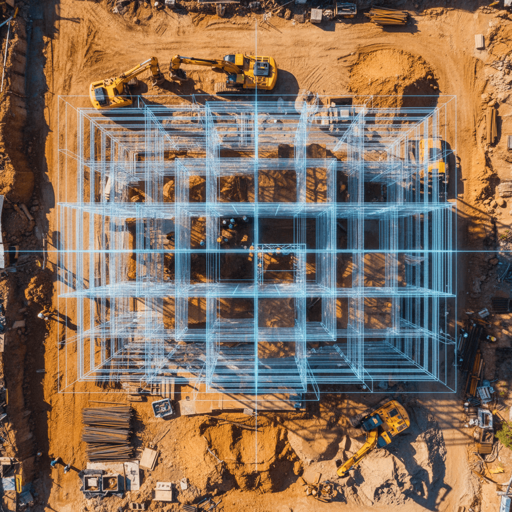
Once flight data is offloaded, photogrammetric software such as Pix4D or Agisoft Metashape reconstructs the scene using structure-from-motion algorithms. Overlapping images taken at precise intervals are matched by common feature points, producing a dense point cloud that can contain hundreds of millions of measured positions across a single site. From that point cloud, the software derives the orthomosaic and surface models described earlier, with checkpoint coordinates applied to validate that positional accuracy is holding within specification.
The next stage is classification and format conversion. For BIM integration, the point cloud is segmented by feature type, terrain, structures, temporary works, then exported into IFC or RVT formats compatible with Autodesk Revit and other BIM authoring platforms. Project engineers can overlay this as-built drone dataset directly onto their design model, comparing actual site conditions against the intended geometry. Deviations in earthworks grades, structural positions, or encroachment issues become visible before they compound into rework costs.
For GIS deliverables, the same dataset is exported as georeferenced GeoTIFF orthomosaics and shapefiles ready for ingestion into ArcGIS or QGIS. This allows planning teams and site managers to query spatial relationships, extract contours, and feed updated terrain data into drainage or infrastructure design tools.
Majed Aerial Solutions delivers both GIS and BIM-compatible datasets as standard outputs on every mapping engagement, including projects managed under our construction monitoring service. The data arrives structured for the workflows your engineering team is already using, not as raw files requiring additional conversion.
Thermal Drone Inspection for Industrial and Solar Assets in Riyadh

Geospatial datasets and BIM-compatible outputs address the survey and design side of a construction project. But as Riyadh sites move into MEP installation, envelope completion, and handover stages, a different class of inspection requirement emerges, one that RGB cameras cannot satisfy on their own.
Thermal payloads detect temperature anomalies that are entirely invisible to standard imaging sensors. On a live electrical panel, a failing connection generates localized heat that shows clearly in a thermal frame before it becomes a fault. Across a building envelope, thermal bridging or insulation gaps appear as temperature differentials that no walkthrough inspection would reliably catch. In MEP installations, moisture ingress and overloaded circuits both produce thermal signatures that flag the problem at the source rather than after a symptom appears downstream.
The use case that is growing fastest in central Saudi Arabia is solar PV inspection. Riyadh and the surrounding region are accumulating significant installed capacity across commercial rooftops and utility-scale arrays, and each array requires periodic inspection to identify underperforming or defective cells. A technician with a handheld thermometer walking row by row across a large installation takes days. A drone with a thermal payload covers the same area in hours, reducing inspection time by up to 80 percent while capturing consistent, repeatable data that supports maintenance scheduling.
For this work, enterprise-grade platforms such as the DJI Matrice 350 RTK paired with the Zenmuse H20T provide simultaneous thermal and RGB capture, enabling dual-channel analysis that ties every thermal anomaly to a precise georeferenced location in the visible-light record. That combination makes fault reporting specific enough to act on immediately.
Majed Aerial Solutions delivers this capability through our thermal inspection service, structured for both one-off condition assessments and recurring maintenance programmes on industrial and energy assets across Riyadh.
Construction Site Monitoring: Weekly Progress Tracking and Volumetric Analysis

Thermal inspection addresses asset condition at a point in time. Construction site monitoring applies the same aerial capability as a recurring discipline across the full build programme, producing a data-backed record that accumulates value with every flight.
The recurring-mission model is straightforward: drones fly over an active site on a weekly or bi-weekly schedule, capturing consistent orthomosaics and surface models from the same flight paths each time. Those repeat datasets feed directly into volumetric analysis tools that calculate stockpile quantities, quantify cut-and-fill movement against design grades, and flag earthworks that are running ahead of or behind programme. The GIS diff-comparison between two consecutive orthomosaics makes earthworks movement visible and measurable without a surveyor re-occupying the site.
For project owners managing multiple concurrent contractors across a large Riyadh site, this kind of neutral third-party aerial record carries particular weight. Disputes over quantities completed, sequence deviations, or encroachment between contractor zones can be resolved against a time-stamped photographic and spatial audit trail rather than competing claims from parties with conflicting interests. On drone mapping construction Riyadh engagements at the scale now common across the city, that audit function alone justifies the monitoring programme.
Manual progress reporting relies on site walkthroughs, photography from ground level, and surveyor re-measurement of selected zones. The result is partial coverage, delivered slowly, with no consistent spatial reference tying one report to the next. Weekly drone monitoring replaces that process with full-site coverage, delivered as structured geospatial data, on a schedule that keeps pace with actual construction activity.
Majed Aerial Solutions structures this capability through our construction monitoring service, designed to integrate with your existing project reporting cycle from mobilisation through handover.
Aerial Photography and 6K Videography for Construction Documentation

Progress data and inspection records serve the engineering team. But every active Riyadh construction project also has an audience beyond the site fence: government stakeholders, private investors, development authority reviewers, and communications teams who need broadcast-quality visuals to tell the project's story at each milestone.
6K aerial video and high-resolution photography serve that need directly. A combined flight mission captures mapping data on the primary passes, then adds cinematic footage runs across the same site without a separate mobilisation. The result is a single engagement that produces both engineering-grade geospatial data and investor-ready visuals, which is a significant cost efficiency when compared to commissioning two separate operations.
For real estate developers and project owners presenting to government bodies or private capital, the visual context matters. Aerial footage over a North Riyadh mixed-use development, a site in the Al Diriyah buffer zone, or a commercial tower rising along King Fahd Road communicates scale and progress in a way that ground-level photography cannot replicate. These visuals carry weight in board presentations, milestone reports, and media releases.
Majed Aerial Solutions delivers this through our aerial photography service, structured to complement mapping and monitoring engagements rather than sit apart from them.
Live Aerial Broadcasting for Construction Milestones and Site Events

Milestone events on large Riyadh construction sites have moved well beyond a small gathering and a photo opportunity. Topping-out ceremonies, foundation-laying events, and project handover occasions are now production events, often broadcast live to government stakeholders, investor groups, and media simultaneously. A static ground-level camera feed does not capture the scale that these moments require.
Drone-integrated live broadcasting solves that directly. Real-time aerial video transmission feeds into event AV systems, giving producers a dynamic overhead perspective that communicates site scale, progress, and context in a single frame. For a developer announcing a milestone on a North Riyadh mixed-use scheme, or a government body marking the launch of a major infrastructure programme, that aerial feed carries weight that no ground camera can replicate.
Majed Aerial Solutions provides live aerial broadcasting for exactly these occasions, with all operations conducted under GACA regulatory compliance and coordinated in advance with event production and AV teams. Flight authorisations, airspace coordination, and transmission setup are handled as part of the service, so event organizers are not managing a separate technical workstream on the day.
GACA Licensing and Why It Matters for Your Construction Project
The live broadcast capability completes the event-facing side of the service picture. Behind it sits a compliance layer that determines whether any of these operations can legally take place at all.
All commercial drone operations in Saudi Arabia require GACA certification at two levels: the remote pilot must hold a current Remote Pilot Certificate, and the operating entity must hold a commercial operator license covering the specific aircraft types being flown. These are separate certifications with separate fee structures published directly by GACA, and both must be current at the time of each flight. Procurement teams reviewing drone service contracts should request copies of both before any mobilisation is approved.
Unauthorized drone flights on construction sites carry real consequences. GACA enforcement can result in fines, equipment confiscation, and in cases involving sensitive airspace, project-level disruption that extends well beyond the drone operator.
Working with a licensed operator transfers the compliance burden cleanly. For every drone mapping construction Riyadh engagement, Majed Aerial Solutions handles flight permit applications, airspace coordination submissions, and insurance documentation as part of the service. Clients receive copies of all permits relevant to their site, which satisfies the audit requirements most large Saudi construction contracts impose on subcontractors and specialist service providers.
Commercial liability insurance is a separate but related requirement. Licensed operators carry this coverage as a condition of their operating certification, making it a straightforward procurement checkbox rather than a negotiation on each engagement.
Choosing a Drone Mapping Partner in Riyadh: Key Questions to Ask
With compliance requirements confirmed, the practical question becomes which operator to appoint. Most articles covering drone mapping construction Riyadh projects stop at technical specifications without giving procurement teams the questions that actually separate capable operators from those who will create problems mid-programme.
Before approving any mobilisation, ask these six questions directly.
Are both the remote pilot certificate and the commercial operator license current? Request copies. GACA certifications have defined validity periods, and an expired certificate exposes your project to enforcement risk regardless of how professional the operator appears.
What file formats are delivered, and are they BIM and GIS compatible? Deliverables should include georeferenced GeoTIFFs, point clouds in LAS or LAZ format, and IFC or RVT exports for BIM ingestion, not raw imagery that requires your team to process.
What is the stated accuracy specification, and how is it validated? A credible operator provides a checkpoint report alongside every survey dataset showing measured versus expected position values at independently verified control points.
Does the operator carry commercial liability insurance? This is a standard procurement requirement on most large Saudi construction contracts and should be confirmed before contract signature.
Can they commit to a recurring weekly monitoring schedule, or only one-off flights? Single surveys have limited value on an active site; a programme delivering consistent repeat coverage is a different operational commitment.
Do they have documented experience on large Riyadh infrastructure projects? Familiarity with local airspace, site access protocols, and the data formats expected by regional project owners materially affects delivery quality.
Majed Aerial Solutions is structured to answer all six questions affirmatively, delivering licensed, insured, and format-ready outputs through our construction monitoring service on schedules that match your build programme from mobilisation through handover.
Implementing high-precision drone technology is no longer just an option for modern projects in Riyadh; it is a necessity for staying competitive and accurate. By leveraging RTK surveying and BIM-ready data, you can streamline your workflows and reduce costly errors. If you want expert help to navigate these complex aerial workflows, Majed Aerial Solutions is here to support your team. Exploring our specialized Construction Monitoring services is a natural next step to ensure your site data remains reliable and actionable throughout every phase of development.