Saudi engineering teams need centimeter-accurate 3D models that integrate seamlessly with software like Autodesk and Bentley to enable real-time site intelligence and progress monitoring. Implementing a BIM ready digital twin drone Saudi Arabia solution allows projects to compare actual site conditions against design models, track earthwork volumes, and maintain timestamped records for risk management on large-scale developments.
For many Saudi engineering firms, the promise of drone technology often ends at a folder full of visually impressive imagery that cannot be imported into a functional BIM environment. This persistent gap between raw data and actionable intelligence creates significant friction during large scale infrastructure projects where precision is non-negotiable. At Majed Aerial Solutions, we understand that a model is only as valuable as its seamless integration with your existing Revit or Civil 3D workflows. As Saudi Arabia accelerates its urban expansion, the transition from simple aerial views to BIM-ready digital twins is now a necessity for meeting rigorous GEOSA standards. This article explores the critical requirements for high-accuracy drone data; we address the ±1 to 3 cm threshold for GCP validation, essential deliverable formats for local consultants, and the regulatory frameworks governing complex aerial surveys in the Kingdom.
Moving Beyond Pretty Pictures: The Rise of the BIM-Ready Digital Twin in Saudi Arabia
Saudi Arabia is currently undergoing a massive infrastructure transformation driven by Vision 2030. Giga-projects like NEOM, Qiddiya, and New Murabba operate on aggressive timelines that leave no room for manual measurement errors or data silos. Consequently, the industry is rapidly moving away from basic aerial photography toward high-fidelity, engineering-grade assets.
For a Saudi engineering team, a visual model is only as valuable as its data integrity. A BIM ready digital twin drone Saudi Arabia deployment must go beyond surface-level visuals to include the precise spatial accuracy and metadata required for actual design and construction workflows. Basic imagery cannot facilitate clash detection or volume calculations. True reality capture services provide the foundational data needed to bridge the gap between design intent and as-built reality.
Majed Aerial Solutions provides this critical bridge through professional RTK aerial surveying and 3D photogrammetry and BIM modeling. Our operations are uniquely positioned in the Kingdom; we hold dual licensing from GACA (UA-38575) and GEOSA. This ensures that every point cloud and mesh we deliver is not just technically precise but also legally valid for official engineering submissions to government entities and lead consultants. In a landscape where precision determines project velocity, we ensure your digital twin is a functional engineering tool, not just a visual reference.
Is a Digital Twin the Same as a BIM Model? Clearing the Confusion
In the context of Saudi giga-projects, many professionals mistakenly use these terms interchangeably. However, they serve distinct yet symbiotic roles. BIM is primarily a process and a 3D model representing the design intent; it dictates how a structure should be built. Conversely, a digital twin is the living as-built representation of the project at a specific point in time.
For a BIM ready digital twin drone Saudi Arabia workflow to succeed, it must facilitate a bidirectional flow of information. Our reality capture services utilize a professional fleet to record the physical state of the site with high precision. This data is then overlaid onto the BIM model to identify discrepancies. This comparison is critical in Riyadh’s fast-moving construction sector; a deviation in foundation placement or utility alignment can lead to millions of SAR in rework if not caught before the next phase of construction begins.
Feature | Building Information Modeling (BIM) | Digital Twin (Drone-Captured) |
|---|---|---|
Primary Purpose | Design intent, planning, and coordination. | Operational reality and performance monitoring. |
Temporal Nature | Often static for a specific design phase. | Dynamic; evolves via recurring drone updates. |
Data Source | Architect and engineer parameters. | Drone sensors, photogrammetry, and LiDAR. |
Core Function | Tells the contractor what to build. | Tells the stakeholder what actually exists on-site. |
By integrating these two systems through 3D photogrammetry and BIM modeling, Saudi engineering teams move from a reactive posture to a proactive one. The digital twin acts as the single source of truth for the project's current status, ensuring that the living site data continually informs and validates the master design model.
The Accuracy Threshold: Why ±1 to 3 cm with GCP Validation is Non-Negotiable
 to validate ±1-3cm drone data accuracy.")
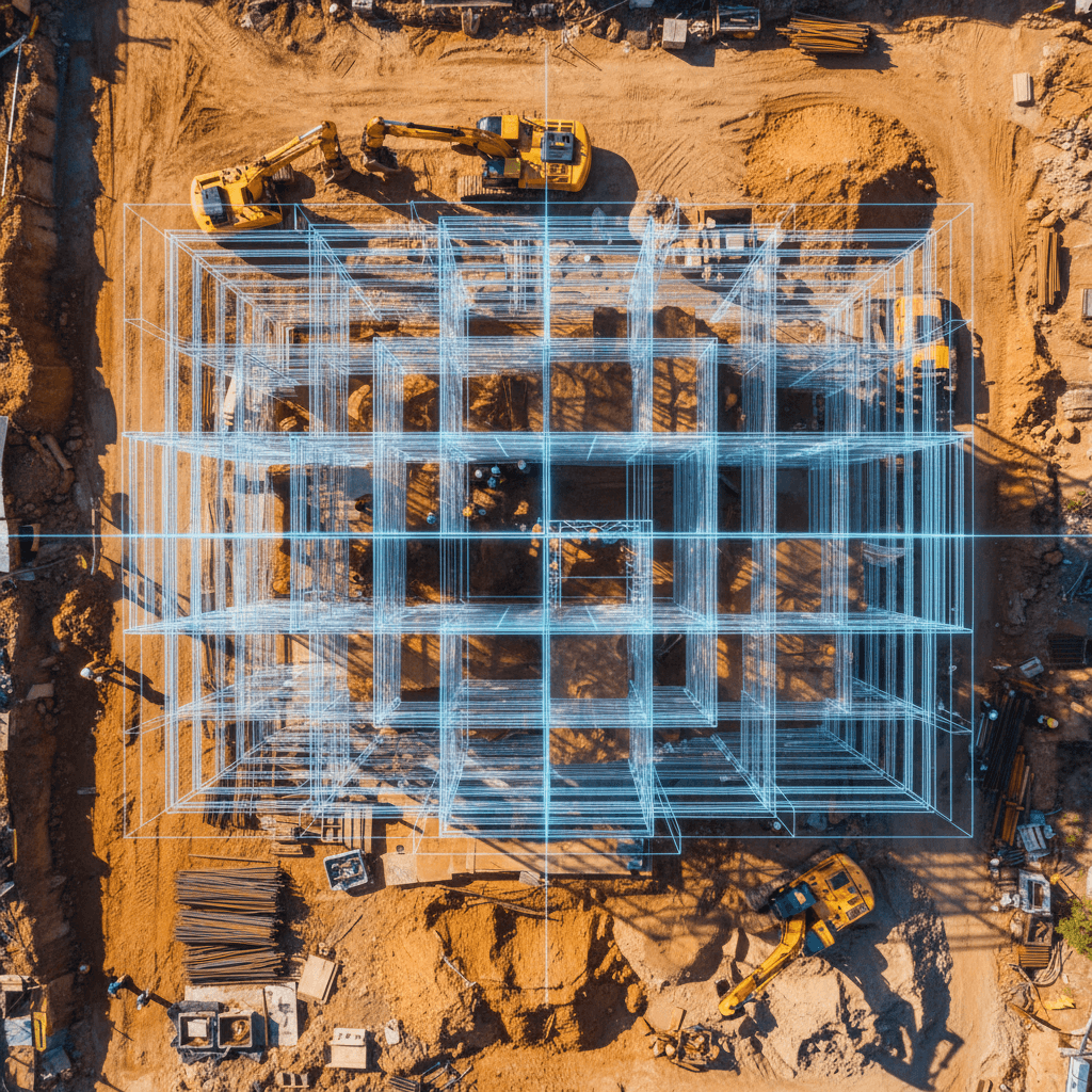
For a digital model to function as a legitimate engineering asset, it must exceed the threshold of visual representation and enter the realm of absolute spatial certainty. To achieve a BIM ready digital twin drone Saudi Arabia standard, we rely on professional RTK aerial surveying as the baseline. While Real-Time Kinematic (RTK) technology provides real-time corrections to the drone’s position, it is not a standalone solution for engineering-grade deliverables. The true differentiator between a visual map and a BIM-ready model is the rigorous application of Ground Control Points (GCPs) for validation.
At Majed Aerial Solutions, our 8-drone professional fleet operates on a protocol where RTK data is cross-referenced against physical GCPs measured by high-precision GNSS rovers. This process ensures that the resulting 3D mesh or point cloud achieves a horizontal and vertical accuracy of ±1 to 3 cm. Without this validation, a model may appear internally consistent but remain shifted in absolute space, rendering it useless for complex tasks like pipe networking or structural alignment.
This precision is particularly vital given the environmental variables in the Kingdom. The Saudi desert presents high solar reflectivity and shifting sand terrains that can interfere with standard photogrammetry algorithms, often creating "noise" or artifacts in the data. Our 3D photogrammetry and BIM modeling workflows mitigate these challenges by utilizing high-overlap flight patterns and advanced sensor calibration. For giga-projects and urban infrastructure in Riyadh, this accuracy ensures that when a consultant overlays as-built data with design intent, every detected deviation is a real-world site issue rather than a measurement error.
From Point Clouds to Revit: Essential Deliverable Formats for Saudi Consultants

Raw drone data is only as valuable as its compatibility with the engineering ecosystem. To ensure a BIM ready digital twin drone Saudi Arabia workflow is successful, Majed Aerial Solutions employs a rigorous Scan-to-BIM process. This transition begins with raw photogrammetric data, which we process into high-density LAS or LAZ point clouds. These points are then converted into textured 3D meshes and, finally, into intelligent parametric models that Saudi consultants can manipulate within their existing software environments.
Our deliverables are optimized for the Autodesk AEC Collection and Bentley Systems, which serve as the backbone for most KSA giga-project workflows. We provide the specific formats required for multi-disciplinary coordination:
Deliverable Category | Common File Formats | Use Case in KSA Projects |
|---|---|---|
Point Clouds | .LAS, .LAZ, .RCP | Foundation for Scan-to-BIM and topographic analysis. |
Vector/CAD Data | .DWG, .DXF | Site layouts and architectural floor plans. |
Parametric BIM | .RVT, IFC | Integration into Revit for design validation. |
Coordination | .NWD, .NWC | Clash detection within Navisworks environments. |
We recognize that excessively large, unoptimized files can crash a consultant’s workstation and stall progress. Therefore, we emphasize providing "clean" data through our 3D photogrammetry and BIM modeling services. By filtering noise and optimizing mesh topology, we deliver engineering-grade assets that remain lightweight enough for fluid navigation while maintaining the ±1 to 3 cm accuracy required for official project documentation.
Weekly Progress Monitoring and Clash Detection in Riyadh's Urban Expansion

The velocity of Riyadh's urban expansion requires more than static data; it demands temporal intelligence. By implementing recurring flight schedules, project managers transform a BIM ready digital twin drone Saudi Arabia deployment into a dynamic monitoring tool. Our reality capture services typically operate on weekly or bi-weekly cycles, providing a continuous stream of as-built data that reflects the true state of the site.
This frequency enables high-resolution clash detection. By overlaying the current drone-captured geometry onto the original BIM design model, engineering teams can identify structural deviations, such as a misaligned pillar or an encroaching utility line, before the next construction phase begins. In complex infrastructure projects like the Riyadh Metro, where underground utilities and surface structures must align perfectly, catching a minor deviation early prevents cascading delays and substantial rework costs.
Temporal data is as critical as spatial accuracy for the evolution of the Riyadh skyline. It allows stakeholders to track volumetric changes in earthworks, monitor subcontractor productivity, and provide verifiable progress reports to government bodies. Through 3D photogrammetry and BIM modeling, we provide the visual and mathematical evidence needed to synchronize the physical site reality with the project's digital master plan, ensuring that the finished structure matches the intended design precisely.
Legal and Regulatory Compliance: The GEOSA and GACA Mandate
Maintaining a high-fidelity BIM ready digital twin drone Saudi Arabia workflow requires more than technical hardware; it necessitates strict adherence to the Kingdom’s regulatory framework. Many international firms operating in Riyadh underestimate the necessity of local licensing for reality capture. In Saudi Arabia, commercial drone operations must be authorized by the General Authority of Civil Aviation (GACA), while the collection and processing of geospatial data fall under the jurisdiction of the General Authority for Survey and Geospatial Information (GEOSA).
Submitting surveying reports or 3D models generated by unlicensed operators can lead to severe project delays, legal penalties, or the outright rejection of data by government entities. Majed Aerial Solutions (CR 7052338246) mitigates these risks for engineering lead contractors by maintaining full compliance. We are dual-licensed by GACA (Registration UA-38575) and GEOSA, ensuring that our reality capture services and professional RTK aerial surveying meet the legal standards required for official submissions. Furthermore, our GAMR license (Reg. 646781) for media operations provides a comprehensive legal framework for 3D photogrammetry and BIM modeling deliverables, protecting the integrity of your project's digital documentation.
Specialized Intelligence: Thermal and Hydrological Layers for a Smarter Twin

A sophisticated BIM ready digital twin drone Saudi Arabia deployment extends beyond visible light to include the electromagnetic spectrum. For high-rise developments in Riyadh or energy facilities in the Eastern Province, Majed Aerial Solutions integrates radiometric thermal data into the 3D model. This allows engineers to identify thermal bridging in building envelopes, monitor HVAC efficiency, or detect subsurface moisture ingress that compromises structural integrity. By merging thermal layers with 3D photogrammetry and BIM modeling, stakeholders gain a diagnostic tool that identifies performance issues invisible to the naked eye.
Environmental intelligence is equally vital for developments situated near wadis or expansive landscaped zones. Our reality capture services utilize multispectral sensors to monitor vegetation health and irrigation efficiency, a critical factor for the Kingdom's sustainable urban projects. Furthermore, we provide HEC-RAS hydrology modeling derived from professional RTK aerial surveying.
Sensor Layer | Data Output | Engineering Application |
|---|---|---|
Radiometric Thermal | Temperature Gradients | HVAC audits and structural integrity. |
Multispectral | NDVI / Vegetation Indices | Sustainable landscaping and urban forestry. |
Hydrological (HEC-RAS) | Flood Risk Simulations | Wadi-adjacent site safety and drainage design. |
This high-resolution topographical data allows consultants to simulate flood risks and runoff patterns within the digital twin environment. These specialized layers transform a standard model into a predictive intelligence platform, ensuring infrastructure remains resilient against both extreme heat and the periodic flash flood risks characteristic of the region.
In summary, successfully integrating drone data into your BIM pipeline requires more than just high-end hardware; it demands a deep understanding of data accuracy and local project standards. If you want expert help navigating these technical requirements, we provide comprehensive 3D Photogrammetry & BIM Modeling Riyadh services to bridge the gap between aerial capture and actionable engineering models. This ensures your project stays on schedule while maintaining the highest level of precision throughout the construction lifecycle.