Thermal drone inspection Saudi Arabia enables industrial operators to detect critical hotspots and structural faults in solar panels and oil pipelines with high-resolution accuracy. These GACA-licensed services drastically reduce inspection times from weeks to mere hours; this efficiency supports Vision 2030 goals while maximizing energy ROI and ensuring asset integrity across the Kingdom.
When a failing solar cell, an overheating pipeline joint, or a degraded electrical connection goes undetected, the cost is rarely just the repair bill. In Saudi Arabia's extreme heat environment, asset failures accelerate, and traditional inspection methods that require shutdowns, scaffolding, or manual walkovers simply cannot keep pace with the scale of modern energy and industrial infrastructure. Thermal drone inspection changes that equation entirely. In this guide, you will learn exactly how radiometric thermal imaging works from a drone platform, what fault types it reliably detects across solar farms, oil and gas pipelines, and industrial equipment, what a professional inspection report contains, and what pricing looks like when you work with a GACA-licensed operator in Saudi Arabia.
What Is Radiometric Thermal Drone Inspection and Why It Matters in Saudi Arabia
Most thermal cameras produce a visual heat map, a colour-coded image that tells an inspector something is warm. A radiometric thermal camera does something more precise: it records an exact temperature value for every individual pixel in the frame. That distinction matters enormously in practice, because it allows engineers to measure the actual temperature delta between a healthy component and a suspect one, rather than relying on visual contrast alone.
In Saudi Arabia, that precision becomes critical. Ambient temperatures in Riyadh regularly exceed 45°C in summer, desert dust coats equipment surfaces and alters emissivity readings, and intense solar irradiance creates background thermal noise across exposed assets. These conditions make visual thermal interpretation unreliable. Drone-based radiometric data cuts through that noise by recording calibrated, per-pixel temperature values that hold up to engineering scrutiny regardless of ambient conditions.
Mounting a radiometric sensor on a drone adds a second layer of capability: the ability to cover large, often hazardous, or geographically dispersed assets at a speed and resolution that ground-based inspection cannot match. For thermal inspection services across Saudi Arabia, the combination of radiometric accuracy and aerial coverage is what separates meaningful inspection data from a basic site visit.
This article covers how that capability applies across three asset categories: utility-scale solar farms, oil and gas pipeline infrastructure, and industrial facilities.
How Thermal Drones Detect Faults in Solar Panels Across Saudi Farms

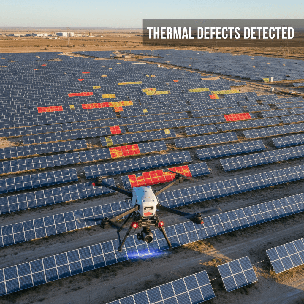
Solar panels are among the assets that benefit most directly from radiometric thermal data. Each fault type produces a distinct thermal signature, and identifying them early prevents yield degradation that compounds quietly across large arrays.
The fault categories detectable through thermal drone solar panel inspection include:
Hotspots: localised cells running significantly hotter than surrounding cells, typically caused by shading, contamination, or cell-level damage
Bypass diode failures: a failed diode forces current through a blocked string, creating a characteristic heated stripe across a module
Cracked PV cells: physical micro-cracks interrupt current flow, showing as cool zones within otherwise active cells
Soiling patterns: dust accumulation across Saudi Arabia's desert sites creates partial shading signatures that thermal imagery maps precisely across rows
Delamination: moisture or air trapped between laminate layers appears as irregular thermal gradients across module surfaces
String-level underperformance: entire strings producing lower output show as cooler or inconsistently heated rows relative to adjacent performing strings
Timing is not optional. Inspections need to occur between approximately 10am and 2pm in Riyadh, when solar irradiance is high enough to generate a meaningful delta-T between healthy and faulty cells. Flying outside that window compresses temperature differentials and reduces fault detectability.
The scale advantage is significant. A single drone flight covers up to 1 MW of installed panels in roughly 10 minutes. A 100 MW farm that would take weeks to walk manually can be fully surveyed in a structured operational day. That efficiency matters directly for projects under Saudi Arabia's National Renewable Energy Program and the large-scale installations planned across NEOM and other Vision 2030 developments, where asset managers need repeatable, rapid inspection cycles across hundreds of megawatts.
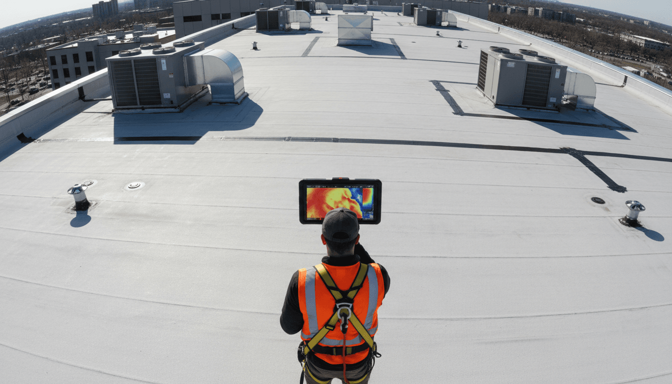
As a GACA-licensed operator based in Riyadh, Majed Aerial Solutions can fly legally over utility-scale solar installations with the airspace coordination those sites require. Inspection reports are delivered with annotated thermal imagery, GPS-tagged fault locations, and severity classifications structured for compatibility with standard asset management platforms.
Pipeline and Oil and Gas Infrastructure: Drone Thermal Inspection Without Shutdown

Yes, thermal drones can inspect active pipelines without any operational shutdown. The drone flies the pipeline corridor at low altitude while the radiometric sensor continuously records temperature data across the pipe surface, insulation jacket, and surrounding ground. Anomalies that indicate leaks, corrosion hotspots, insulation failures, or pressure irregularities appear as measurable temperature differentials in the captured dataset, which engineers can then review against baseline readings. The pipeline keeps running throughout.
The time reduction this enables is substantial. Drone inspection oil gas pipelines Saudi Arabia-based operators have benchmarked inspections that previously consumed two weeks of manual work completing in approximately four hours using structured drone operations with automated flight paths. For linear infrastructure stretching across desert terrain, that compression in inspection time has direct consequences for maintenance scheduling, HSE reporting cycles, and operational continuity.
Safety is the other side of that equation. Manual pipeline inspection in Saudi Arabia's industrial environment requires personnel to walk exposed corridors in extreme heat, and in refinery or processing contexts, to climb flare stacks and elevated structures. Drone operations remove that exposure entirely. The aircraft carries the sensor; the operator works from a safe ground position. According to industry data, drone adoption in oil and gas inspection has been associated with reductions in inspection-related accidents of up to 91 percent.
What makes the data useful at an engineering level is the combination of sensors. Thermal and visual RGB cameras operate simultaneously, producing a dual-layer dataset: the thermal layer identifies where anomalies exist, and the RGB layer provides the structural context an engineer needs to classify the fault and plan a response. That pairing matters for the kind of detailed review that supply chain infrastructure supporting operations like those run by Saudi Aramco and SABIC demands.
Georeferenced thermal data is delivered with GPS coordinates pinned to each identified anomaly, so maintenance teams can locate the exact section of pipe requiring intervention without a secondary site visit. Our aerial survey and inspection solutions are structured to deliver that level of specificity as a standard output, not an optional add-on.
Industrial Asset Inspection: Electrical Switchgear, Transmission Lines, and Process Equipment
Pipeline and solar coverage represents the most visible slice of thermal drone work, but a significant portion of the industrial asset base across Saudi Arabia sits in a different category entirely: high-voltage transmission infrastructure, electrical switchgear, and process plant equipment. These assets receive comparatively little attention in most drone inspection coverage, which is exactly where the inspection gap tends to widen.
On high-voltage transmission lines, the fault types that matter most are failing insulators and overheating conductor splices. A degraded insulator creates a measurable thermal signature before it fails completely; a poorly made or corroded splice junction runs hotter than the surrounding conductor under load. Both are detectable through radiometric thermal data captured at safe standoff distances, without taking lines out of service or sending crews into proximity with energised infrastructure.
Electrical switchgear and substations present a different geometry but the same underlying logic. Failing contactors, overloaded bus bars, and loose terminations all produce resistance-driven heat that a calibrated radiometric sensor can quantify precisely. Substation thermography conducted via drone removes the need for personnel to work inside live enclosures, which is a meaningful safety improvement given the fault conditions that prompt the inspection in the first place.
Process plant equipment, including heat exchangers, boilers, and pressure vessels, rounds out the picture. Thermal gradients across heat exchanger surfaces indicate fouling or tube bundle degradation. Refractory breakdown inside boiler casings shows as external hot spots. These signatures are subtle enough that they require radiometric precision rather than visual thermal interpretation to classify reliably.
For industrial drone inspection Saudi Arabia-based operations, the corridor stretching from Riyadh toward Jubail concentrates exactly these asset types across remote and often hazardous terrain. Manual inspection in those environments carries both safety exposure and significant mobilisation cost. Drone-delivered georeferenced reports, with GPS coordinates attached to each identified fault, allow maintenance teams to dispatch directly to the relevant asset location without a preliminary site walk. That specificity is built into every dataset our aerial survey and inspection solutions produce as a standard deliverable.
What Defect Types Show Up on a Thermal Drone Inspection Report

The defects that appear in a radiometric thermal inspection report are not a single category. They span different physical failure mechanisms, each with its own thermal signature and severity threshold. Understanding that distinction is what separates a useful inspection report from a list of flagged images.
The main defect categories identified through thermal drone inspection include:
Thermal anomalies in electrical connections: resistance faults at terminations, corroded contacts, or loose connections generate localised heating under load. On switchgear or transmission splices, these appear as discrete hotspots with sharply bounded temperature gradients.
Insulation degradation: failing thermal insulation on pipelines or process vessels shows as elevated surface temperature along the degraded section, with the heat loss signature proportional to insulation thickness remaining.
Fluid leaks in pipelines: escaping product creates a temperature differential against the surrounding ground or structure. Whether the product is hotter or cooler than ambient determines whether the signature appears as a hotspot or a cool anomaly.
Mechanical friction hotspots: rotating equipment with bearing wear or misalignment generates frictional heat that radiometric sensors detect before mechanical failure occurs.
Moisture ingress: flat roofing and building envelopes retain heat differently when water is trapped beneath the membrane, producing irregular thermal gradients that appear clearly during post-sunset cooling cycles.
Temperature delta thresholds determine how defects are classified. On solar PV assets, a delta-T above 10 degrees Celsius on a single cell relative to adjacent cells is generally classified as a critical fault requiring immediate action under IEC 62446-3 guidance. A delta-T between 3 and 10 degrees Celsius typically indicates a moderate fault warranting scheduled intervention. Below 3 degrees Celsius falls into a monitoring category.
Majed Aerial Solutions structures inspection reports with annotated thermal maps, GPS-tagged defect coordinates, and severity classifications aligned with IEC and ISO thermography standards, so maintenance teams receive data they can act on directly rather than raw imagery requiring further interpretation.
GACA Licensing and Why It Matters for Commercial Thermal Inspections in Saudi Arabia

Knowing what defects look like in a radiometric dataset is only half the operational picture. The other half is whether the operator collecting that data is legally permitted to do so over the asset in question.
The General Authority of Civil Aviation requires all commercial drone operators in Saudi Arabia to hold valid operator certificates before conducting any paid flight operations. This is not an administrative formality. Operating without a license over industrial sites, energy infrastructure, or pipeline corridors is a regulatory violation that carries real consequences: projects can be halted mid-inspection, insurance claims tied to incidents on site can be voided, and clients can face HSE compliance exposure for engaging an unlicensed contractor.
For assets like refineries, substations, and utility-scale solar installations, the stakes are higher still. These sites frequently sit within restricted or controlled airspace zones that require formal coordination with GACA before any flight can take place. A GACA licensed drone inspection Riyadh-based operation like Majed Aerial Solutions handles that coordination as part of the standard pre-flight process, so clients are not carrying that regulatory burden themselves.
Licensed operators also carry commercial aviation liability insurance, which matters when operations take place over high-value or safety-critical infrastructure. The documentation that comes with a licensed engagement, including flight records, insurance certificates, and operator credentials, can be submitted directly into a client's HSE compliance records.
For projects operating under Vision 2030 oversight, whether government-led or through quasi-government entities, a licensed operator is typically a formal procurement requirement rather than a preference. Engaging GACA-licensed drone services across Saudi Arabia is what keeps an inspection project legally defensible from the first flight to the final report.
Thermal Drone Inspection Cost in Saudi Arabia: What Drives Pricing
With GACA compliance established, pricing is often the next practical question. Thermal drone inspection cost in Saudi Arabia varies based on several defined factors, and understanding them makes it easier to scope a project accurately before requesting a quote.
The primary cost driver is asset scale. Solar farm inspections are typically scoped by megawatt capacity; pipeline inspections by linear kilometre; industrial asset inspections by number of discrete assets or structures. A 10 MW solar array requires a fundamentally different flight plan and data volume than a 200 MW installation, and pricing reflects that directly.
The second driver is access and airspace complexity. Sites within controlled or restricted zones require formal GACA coordination, which adds pre-flight preparation time. Remote desert sites or elevated structures add mobilisation and operational complexity.
Report depth is the third variable. A basic thermal flyover costs less than a full radiometric report with annotated fault maps, GPS-tagged defect coordinates, and severity classifications aligned to IEC standards. For clients who need that data to feed asset management systems or HSE records, the structured report is the deliverable that matters.
Inspection frequency also affects overall cost. Annual contracts covering multiple cycles across the same asset typically reduce the per-inspection cost compared to single engagements.
Against manual alternatives, the economics are clear. Industry benchmarks consistently show drone-based thermal inspection reducing total inspection costs by 50 to 70 percent compared to scaffolding-based or rope-access thermography, with no operational shutdown required.
Majed Aerial Solutions operates from Riyadh, which eliminates the mobilisation costs that out-of-region operators pass directly to clients. Contact us through our thermal inspection services page for a site-specific quote based on your asset type and location.
Thermal drone technology provides an essential advantage for maintaining industrial infrastructure across Saudi Arabia, ensuring that potential faults are identified long before they cause costly disruptions. While the benefits are clear, achieving high precision requires specialized equipment and GACA licensed expertise. If you want expert help implementing these advanced diagnostic tools into your maintenance workflow, exploring our خدمات التفتيش الحراري is a natural next step. We are here to help you safeguard your assets with professional aerial insights.